🎉 Up to 70% Off Selected ItemsShop Sale

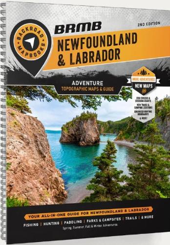
Newfoundland & Labrador Backroad Mapbook
The most easterly province of Canada, Newfoundland and Labrador is a land unlike any other. The Newfoundland and Labrador Backroad Mapbook covers the entire Atlantic province, from the mainland region of Labrador to the proud island of Newfoundland. Here you will discover St. John’s, one of North America’s oldest cities with a European history dating back to the 16th century, and the most easterly point of the entire continent, in Cape Spear. Newfoundland and Labrador boasts the UNESCO World Heritage Site of Gros Morne National Park, where Mother Nature unveils the earth’s mantle amidst spectacular cliffs and glacial valleys. This mapbook includes Bay Roberts, Carbonear, Clarenville-Shoal Harbour, Channel-Port aux Basques, Conception Bay, Corner Brook, Gander, Grand Falls-Windsor, Gros Morne, Happy Valley-Goose Bay, Labrador Highways, Logging Roads, Land & Water Features, Parks, Adventure Points of Interest, Campgrounds, Hiking Trails, Motorized Trails, Paddling Routes, Hunting & Fishing Areas, Winter Recreation and more
$9.97
Original: $28.49
-65%Newfoundland & Labrador Backroad Mapbook—
$28.49
$9.97Newfoundland & Labrador Backroad Mapbook
The most easterly province of Canada, Newfoundland and Labrador is a land unlike any other. The Newfoundland and Labrador Backroad Mapbook covers the entire Atlantic province, from the mainland region of Labrador to the proud island of Newfoundland. Here you will discover St. John’s, one of North America’s oldest cities with a European history dating back to the 16th century, and the most easterly point of the entire continent, in Cape Spear. Newfoundland and Labrador boasts the UNESCO World Heritage Site of Gros Morne National Park, where Mother Nature unveils the earth’s mantle amidst spectacular cliffs and glacial valleys. This mapbook includes Bay Roberts, Carbonear, Clarenville-Shoal Harbour, Channel-Port aux Basques, Conception Bay, Corner Brook, Gander, Grand Falls-Windsor, Gros Morne, Happy Valley-Goose Bay, Labrador Highways, Logging Roads, Land & Water Features, Parks, Adventure Points of Interest, Campgrounds, Hiking Trails, Motorized Trails, Paddling Routes, Hunting & Fishing Areas, Winter Recreation and more
Product Information
Product Information
Shipping & Returns
Shipping & Returns
Description
The most easterly province of Canada, Newfoundland and Labrador is a land unlike any other. The Newfoundland and Labrador Backroad Mapbook covers the entire Atlantic province, from the mainland region of Labrador to the proud island of Newfoundland. Here you will discover St. John’s, one of North America’s oldest cities with a European history dating back to the 16th century, and the most easterly point of the entire continent, in Cape Spear. Newfoundland and Labrador boasts the UNESCO World Heritage Site of Gros Morne National Park, where Mother Nature unveils the earth’s mantle amidst spectacular cliffs and glacial valleys. This mapbook includes Bay Roberts, Carbonear, Clarenville-Shoal Harbour, Channel-Port aux Basques, Conception Bay, Corner Brook, Gander, Grand Falls-Windsor, Gros Morne, Happy Valley-Goose Bay, Labrador Highways, Logging Roads, Land & Water Features, Parks, Adventure Points of Interest, Campgrounds, Hiking Trails, Motorized Trails, Paddling Routes, Hunting & Fishing Areas, Winter Recreation and more